Overview
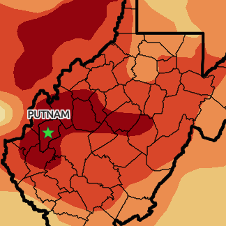
This is an ESRI StoryMap I created to shed light on the severe drought in Putnam County, West Virginia in the summer of 2024. The interactive map provides detailed information on how the drought is impacting farmers in the region, highlighting the challenges they face due to water scarcity and reduced crop yields.
Using the blog format combined with visuals and data, the story map sheds light on the severity of the situation and its implications for the agricultural community in Putnam County.
Relief Resources
This story map also serves as a valuable resource by including links to several organizations that are actively involved in providing relief to the affected farmers. These organizations offer assistance in various forms, such as providing emergency water supplies, distributing drought-resistant seeds, and offering financial support to help farmers cope with the impact of the drought.
By connecting users to these relief efforts, the story map not only raises awareness about the crisis but also encourages support and collaboration among different stakeholders to address the challenges faced by the farming community in Putnam County.